|
|

|
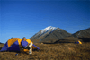
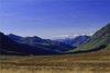
The DeHaviland Beaver lifted off Folly Lake with ease and gracefully banked it's wing to the right and wove it's way between two unnamed mountains and climbed steadily up through the valley and was quickly out of sight. I stood there for a moment taking in the incredible sight of this vast wilderness. I was thinking how beautiful and pleasant this is. It's warm, sunny, and ? But how much fun will this be if the weather really turns bad? | 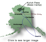 |
| For a brief moment I thought, yikes, what I have done!? I'm over 300 miles from the closest McDonalds and no way out. | ||
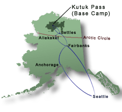
| Click on
any photograph to see a larger image |
|
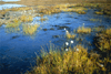
One look at the valley going down the south slope and I instantly thought, this must be the home of the Clan of the Cave Bear as recollections of that prehistoric story began replaying through my brain. I conjured up images of attacking a woolly mammoth for food and looking around to make sure I was safe from any saber toothed cats. Hmmm, a McMammoth burger? Now you really can't super size it any more than that. Folly Lake really is an unnamed lake as are most of the terrain features in and around Kutuk Pass. Folly is an adopted name that the locals use. |
|
|
Not that too many people are here to even call it by name. I spoke with the manifest desk for the Brooks Range Aviation in Bettles and we were the only group to fly into Folly Lake this year. |
|
|
|
Therefore the total population for 2002 was probably only us six. Not counting the pilots that flew us in and out. |

|
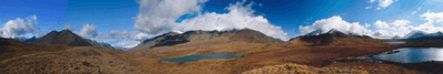
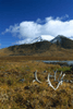
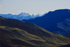
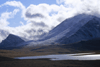
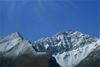
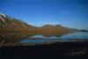
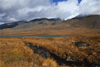
Kutuk Pass is located at 3,500 feet and lies on the Continental Divide. The pass itself is nothing more than a flat grassy area. There's really not a discernible knoll or hill to tell exactly where the division occurs that directs the water flow north to the Arctic Ocean or south to the Pacific Ocean. |
 |
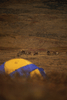
One morning as we sat around camp enjoying a leisurely cup of coffee and slowly working the kinks out from sleeping on the ground. We began talking about the beautiful mountains, lakes, and streams around us that were all unnamed. This has been partially corrected (well at least among the 6 of us). |
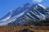
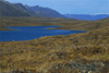
| Hear ye, hear ye, hear ye, let it be known that from this day forward the tallest mountain (at 6,200 ft.) that stands to the SW of Folly Lake will from this day forward be known as "3 John Peak." This is of course, named for the fact that half of the campers on our trip are named John. The US government may not recognize this as a real name but for the 6 of us it will always be remembered as 3 John Peak. We then tried to name the creek Betsy Creek and she said enough. Stop! You only get to name one terrain feature. So there you have it. Tip - If you buy a USGS topological map you will probably need to pencil in the name. |
| Long days and short nights. The late August sun set about 11:30 PM and it was still fairly light even at 3:00 AM, all though this was partially due to a full moon. Even though most days were fairly pleasant it got pretty darn cold at night. I found myself wearing long underwear, an extra fleece layer, a wool hat, and socks to bed each night. Okay so |  |
| now I'm warm and toasty in bed and BOOM. Mother Nature calls. Aw Ma I don't wanna get up its cold outside. Rats, you can't say wrong number when she calls. So I crawl out of my sleeping bag, put on some shoes, and meander outside. I'm standing there "doing my thing" when I hear Jonathan say, "wolf." Where? On the beach. I look down and maybe a couple hundred feet away is a lone light gray wolf. Wow, thanks Mom for waking me up, and thanks Jonathan for being awake and alert. I just saw a wolf in the wild. Cool. Really cool. |
  |
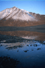
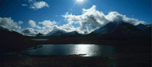
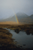
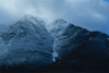
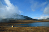
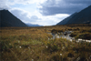
We were really, REALLY lucky with the weather. We had 4 days of almost perfect sunny days, 2 days of kinda gray, partial sun, and one day of total crap. It rained and or snowed for nearly 24 hours. It was plain ol' yucky. I'm not complaining! Not even a little bit. I think we were truly blessed. While the weather in the arctic is unpredictable there is one thing that you can count on, the wind. There again we were fortunate. Yes, the wind blew everyday but we didn't really have a "BAD" windy day. It was always there and it was more than I was use to but it was manageable. After the bad weather day we awoke to dense low clouds and a heavy frost. By mid morning it slowly began to burn off, and as the sun burned through a rainbow formed over the south creek with a promise of good things to come. |
A rainbow formed over the south creek with a promise of good things to come. |
|
|
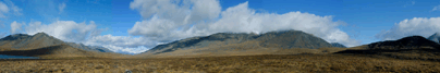
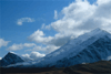
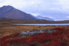
| Finally the sun broke through completely, and we were presented with some of the best scenery of the trip. All of the mountain peaks had a fresh new coat of snow and they were back dropped against a nearly cloudless azure sky. |
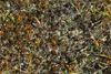
| The tundra was a new experience. It made walking well, different. Most of the time it was not much different than normal ground but there were areas that were definitely, not the norm. | 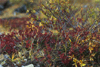
 |
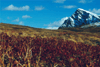
| The one thing that was most noticeable was that in the week we were there many of the scrub plants turned crimson. The tallest treelike plants are only about 12 inches tall but they still add color to the arctic pallet. It's a very different world from what I'm use to and I'm so very happy I've had a chance to experience it. |
|
| Click
here
to cycle through enlarged images of all photographs on this page. |
|
|
| |
||
|
|
||
|
|